Why a West Coast Storm May Be the Start of Something Much Bigger
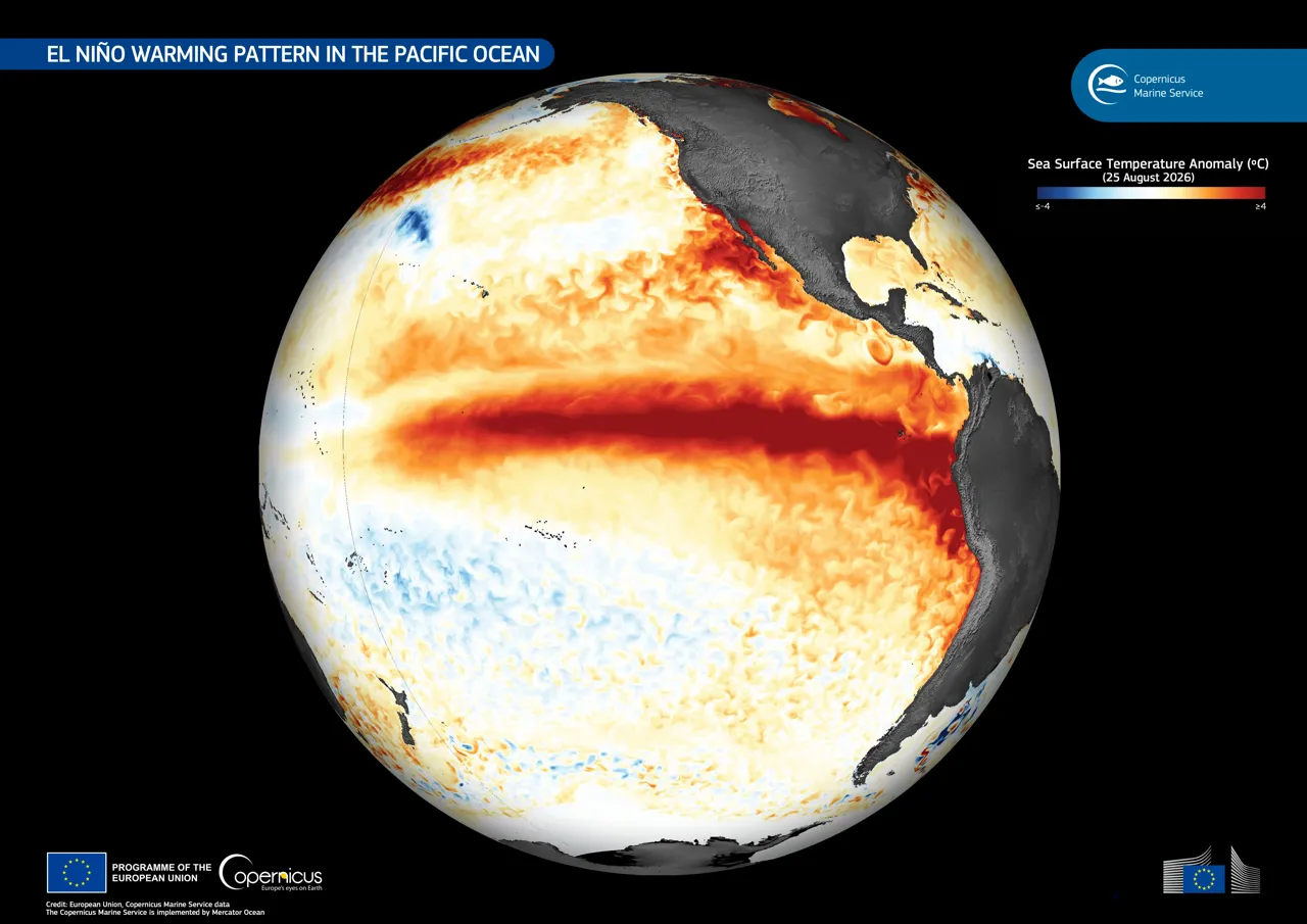
Photo: European Union, Copernicus Marine Service / CC BY · via Wikimedia Commons
Why a West Coast Storm May Be the Start of Something Much Bigger
A Kelvin Wave Is Raising Sea Levels
A deep-ocean Kelvin wave is pushing sea levels higher along the U.S. West Coast, one of the first major signs of this year's "Super El Niño," NPR reported. Dillon Amaya, an assistant professor of atmospheric sciences at North Carolina State University, described it as a "planetary-scale wave" — not a wall of water, tsunami, or surfable wave.
Six to Twelve Inches of Sea Level Rise
The wave can lift background sea levels by roughly 6 to 12 inches (15 to 30 centimeters), bringing warmer water that, because hotter water takes more volume, pushes levels even higher, the Los Angeles Times reported. Phys.org reported the wave can be up to 18 miles (30 kilometers) wide, moving at about 6 miles (9.6 kilometers) per hour, advancing roughly 150 miles (241 kilometers) per day. National Geographic reported Amaya likens it to a pancake, thin and wide.
Two to Four Inches Doubles Flood Risk
Amaya told National Geographic that every 2 to 4 inches (5 to 10 centimeters) of background sea level rise essentially doubles coastal flooding risk in low-lying places. He told AFP, via Phys.org, that the wave raises sea states and, combined with storm surge, large swells, or astronomically high tides, elevates the risk of flooding and beach erosion.
Tropical Storm Rachel Meets the Kelvin Wave
Recent flooding in Orange County resulted not only from swells off Tropical Storm Rachel — downgraded from hurricane status — but also from the El Niño-fueled Kelvin wave that moved slowly up the coast of the Americas from Peru, the Los Angeles Times reported. Patch reported Rachel was the 17th named storm and 10th hurricane of the 2026 Eastern Pacific season. In Long Beach, several beachfront buildings were declared unsafe or restricted, and Newport Beach officials were preparing a local emergency declaration.
Five to Six Waves Expected This Year
Amaya told NPR there are usually five to six Kelvin waves during a strong El Niño year, with several more expected through the fall and early winter. The next wave is predicted to reach San Diego in late October or early November. Patch reported Amaya expects another three to four waves over the coming months, one already moving along Mexico's coastline. PBS reported the waves should continue passing through from October until February.
El Niño Likely Strong Into Early 2027
NOAA researchers predict the El Niño will remain strong through early 2027, NPR reported. Amaya said Kelvin waves usually subside before the peak of El Niño, which typically peaks late in the year or early January.
Atmospheric Rivers on the Way
AccuWeather's Alex DaSilva told USA TODAY the West Coast could see its first atmospheric river as early as mid-November, with the most frequent in January and February. Climate scientist Daniel Swain said he would be surprised by anything in October. Research published in IOP Science found compound flooding events along the Washington and Oregon coasts are nearly twice as high as in southern California, with atmospheric rivers associated with 58 to 72 percent of those events.
What's Next: Compounding Risks
Long Beach Post reported Monday tides near 7 to 7.5 feet with surf of 4 to 6 feet, water levels still 1 to 1.8 feet above predicted tides, driven by El Niño-related thermal expansion, a Kelvin wave, and elevated astronomical tides. Sean Vitousek, a research oceanographer with the U.S. Geological Survey, said higher sea levels combined with large North Pacific swells and seasonal high tides could produce exceptional erosion.
Sources
- El Niño driven Kelvin Wave hits West Coast
- A Pacific 'Blob' is Pulsing Up the West Coast. Here's What's to Expect.
- Tropical Storm Rachel, Kelvin wave, high tides combined to batter SoCal coast
- Sea levels to rise in California as a coastal wave surges up the West Coast
- Kelvin Wave Raises SoCal Sea Levels As Tropical Storm Rachel Threatens Coast